
Embracing the Wild Beauty of North Devon’s Coastal Edge
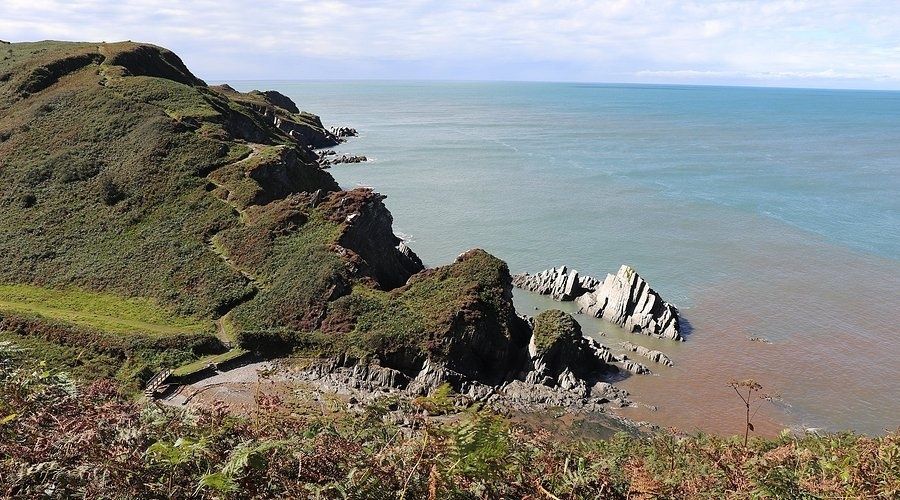
From Ilfracombe, the North Devon coast unfolds in a sequence of dark headlands, bright water and steep green valleys, with the Bristol Channel stretching towards the Welsh coast. The harbour and Victorian seafront can suggest an easy-going seaside outing, yet the moment the route rises into the Torrs, the character changes. Wind presses in from the west, gulls wheel below the path and the land drops sharply towards rocky coves that are beautiful precisely because they remain difficult to reach.
This is a walk for travellers who enjoy the honest physicality of a coastal landscape. The rewards include wide views, quiet farmland, ancient lanes and the sheltered charm of Lee Bay, but the route is not simply a postcard stroll. Steep climbs, slippery ground, exposed sections and fast-moving tides all deserve respect. With sensible preparation, the combination is wonderfully balanced: a bracing day on the headlands followed by the comfort of a warm seaside retreat, a generous meal and somewhere peaceful to let tired legs recover.
Ascending the Seven Hills of Ilfracombe
The initial climb out of Ilfracombe provides an immediate test. Depending on the chosen start, the route threads through Church Hill, Langleigh Road and lanes leading towards the open land above the town, or climbs through Torrs Park onto the South West Coast Path. The ascent is not one continuous staircase, but a succession of rises and dips that can feel more demanding than the map suggests. Local descriptions sometimes refer to the surrounding combes and hills as a series of seven undulations, an apt reminder that progress towards Lee involves repeated changes of level.
Pacing matters more here than speed. Begin steadily, keeping enough energy in reserve for the exposed cliff sections beyond the first viewpoint. Short pauses are worthwhile, particularly at the higher points where the panorama opens across Ilfracombe, the Bristol Channel and, in clear weather, towards Wales and Lundy Island. The scenery can encourage hurried stops in unsuitable places, so choose a firm, set-back section of path before removing a layer or taking photographs.
Footwear should be chosen for grip rather than appearance. After rain, chalky soil, shale and exposed roots can become slick, while narrow paths through grass may conceal ruts or puddled hollows. A waterproof walking shoe may suit a dry summer outing, but boots with ankle support are the more dependable choice in unsettled weather. Keep both hands available on steeper ground, use walking poles if they are familiar, and allow more time than the headline distance implies.
- Start slowly on the first substantial climb and treat the early viewpoint as a pacing check.
- Carry a waterproof layer even when the forecast looks settled, because channel winds can strengthen quickly.
- Use grippy footwear and avoid stepping on the very edge of soft or crumbling ground.
- Keep dogs under close control around livestock, cliff edges and narrow passing places.
- Plan water and food before leaving Ilfracombe, since rural refreshment options are limited outside Lee.
Route Logistics and Terrain Profiles
The direct Ilfracombe to Lee route is approximately three miles, although frequent stops, diversions and the descent towards Lee Bay make the outing feel considerably fuller than the distance suggests. A fit walker may cover the principal route in around an hour of moving time, but two to three hours is more realistic for a relaxed coastal visit with photographs and rests. A circular itinerary combining the old railway trackbed, lanes, woodland, Lee village and the coast path is longer and more varied, commonly requiring half a day or more depending on the exact route and conditions.
There is no single standard elevation figure for every version of the walk. The terrain rises from Ilfracombe into open downland before dropping into Lee and then climbing and falling again along the coast. The former railway route offers a gentler gradient in places, but its history still reflects the area”s challenging topography. The old Ilfracombe to Mortehoe line included a gradient of approximately 1 in 36 and once required double-headed steam trains. Today, the trackbed is a useful, relatively even alternative for walkers wanting to reduce the amount of exposed cliff terrain.
| Route segment | Typical surface | Technical difficulty | Seasonal hazards |
|---|---|---|---|
| Ilfracombe to Torrs and open downs | Town pavements, lanes, steep paths and grass | Moderate, with demanding ascent | Heat, wind, slippery chalk and mud |
| Open downs towards Lee | Field paths, tracks and National Trust land | Moderate | Livestock, wet ground and exposed weather |
| Lee village to Lee Bay | Village lanes and rough access paths | Easy to moderate | Loose stones and wet surfaces |
| Lee Bay along the coastal path | Cliff-top footpaths, grass, rock and rutted sections | Moderate to strenuous | Strong winds, erosion, low visibility and cliff falls |
| Old railway circular alternative | Paved cycleway, country lanes and woodland tracks | Moderate, with a steep wooded section | Roots, ruts, mud and limited transport connections |
Wayfinding is generally manageable, but rural details can slow progress. Expect five-bar gates, livestock fields, stiles, country lanes and occasional areas where a diversion is preferable to crossing directly through a herd. The South West Coast Path is usually clear enough to follow, although coastal erosion can alter the safest line. A map, charged phone and offline route information remain sensible, particularly outside the busier summer months.
Tide Times and the Hidden Inlets of Lee Bay
Lee Bay”s shingle coves and rocky shelves are among the route”s most tempting features, but they must be treated as destinations rather than casual shortcuts. From the higher path, the shoreline can appear close and straightforward. In reality, wet rock, uneven shingle and narrow passages can turn a simple descent into a slow retreat. The Bristol Channel is known for a substantial tidal range, and water can return across apparently accessible ground with surprising speed.
A rescue reported by HM Coastguard demonstrates the consequences of treating a secluded beach as an improvised lunch stop. In December 2023, a couple visiting Lee Bay found the rising tide had cut off their route. As daylight faded and temperatures fell, Coastguard teams from Mullacott and Lynmouth and the RNLI Ilfracombe lifeboat coordinated a rescue, with the lifeboat locating them by searchlight and rope technicians reaching them from the cliffs. The incident is a useful reminder that leaving can be harder than arriving.
Before stepping down from the coastal path, check both the tide and the route back up. Do not rely on a single glance at the water, because wind, swell and the shape of the cove can change the practical timing. The safest decision may be to admire the inlet from above. If conditions deteriorate, return inland while there is still ample daylight and avoid entering water or attempting an unplanned climb.
- Check the local tide times and current coastal safety advice before setting out, using HM Coastguard guidance as part of the planning process.
- Identify the exact entry point and, more importantly, the intended exit route before descending.
- Allow a generous margin around the predicted tide, especially in poor visibility, strong wind or unfamiliar coves.
- Inspect the shoreline from above for narrow passages, seaweed-covered rocks, cliffs and sections that could become isolated.
- Tell someone the intended route and carry a charged phone, spare layer, torch and basic emergency supplies.
- If cut off, move to a safe, visible position, call 999 and ask for the Coastguard, then follow instructions rather than attempting a risky scramble.
Unwinding in the Secluded Charm of Lee Village
Lee feels like a quiet change of pace after the exposed headlands. The approach passes through a sheltered valley where lanes are softened by garden walls, hedges and bright fuchsias. The village has an intimate, settled character, with traditional buildings and a small-scale atmosphere that rewards a slower arrival. Two waymarked approaches can lead walkers into different parts of Lee, while continuing along the lane brings access towards the Lee Bay Hotel and the bay itself.
Refreshment planning is part of the pleasure, but opening times should never be assumed outside the main holiday season. A historic village pub such as the Grampus Inn can provide a natural halfway point for food and a restorative drink, while cream teas and sheltered benches suit a lighter pause. Check availability before relying on a venue, particularly on quieter weekdays. A packed lunch remains useful for the coast path, where the best resting places are often grassy viewpoints rather than formal facilities.
- Book or check opening times if a pub meal is central to the day”s plan.
- Carry a small picnic for flexibility, especially when walking beyond Lee Bay.
- Use village lanes carefully and give way to residents, farm vehicles and horses.
- Consider the return journey before committing to a one-way walk, as rural buses are limited and may operate only on selected days.
- For a circular outing, use the old railway line and inland bridleways where appropriate, while allowing extra time for the steep, rutted descent through woodland.
Public transport is not a dependable last-minute solution in this part of North Devon. A bus connection from Ilfracombe to Lee has historically been limited, with services described as operating only on Tuesdays and Fridays. Timetables can change, so verify them before travelling. Many walkers either arrange a lift, use a taxi in advance or return on foot. Retracing the coastal route offers a second perspective in changing light, while the inland alternative provides more shelter when the channel wind becomes tiring.
Step Out Onto the Headlands Prepared for Every Season
The walk between Ilfracombe and Lee Bay earns its reputation through contrast. It combines the social ease of a seaside town with high, open headlands, secluded coves, working farmland and a village valley that feels wonderfully removed from the main resort. The distance is manageable for many active walkers, but the gradients, exposure and tidal shoreline make preparation essential. Good footwear, spare clothing, food, navigation and a realistic timetable turn a demanding day into a confident one.
Choose a clear weather window where possible, yet do not wait for perfect skies to appreciate the route. Cloud can deepen the drama of the cliffs, while calm winter light reveals the contours of the coast with particular clarity. Walk unhurriedly, stay above the tide unless the beach is unquestionably safe, and leave enough energy for the return. At day”s end, the finest reward may be simple: dry clothes, a satisfying meal and tired limbs warming beside a crackling fire while the wild coast settles beyond the windows.

